
Caught in a Storm of Extreme Events
In Arizona, the summer heat has turned deadly. Public health officials warn that extreme temperatures in Maricopa County may have already claimed more than 400 lives. Across the ocean, Southern Europe is also in crisis, with heatwaves fueling wildfires—including 152 new blazes in Greece alone.
Far to the north, Alaska faced a very different kind of disaster. A lake of rainwater and melting snow burst through a glacial dam near Juneau, unleashing a torrent that pushed the Mendenhall River to its highest level ever recorded. Streets and homes in the city were swallowed by the flood.

Recent heavy rains caused sudden flash floods in Pakistan, killing 337 people. Since late June, powerful monsoon storms have battered the country, especially in the north. The storms set off floods and landslides and forced thousands of families in crowded, low-lying areas to leave their homes. Altogether, floods have already taken more than 600 lives this summer.
And in Texas, July storms unleashed staggering amounts of rain—more in a few hours than Niagara Falls pours out in an entire day. The Guadalupe River surged more than 20 feet, and at least 137 people lost their lives.
Across the U.S. and around the globe, the story is the same: Earth is burning, drowning, and just can’t catch a break from extreme events.
Supercharged by Heat: The Water Cycle Gone Wild
Warmer air increases evaporation, which means that our atmosphere contains an increasing amount of water vapor for storms to sweep up and turn into rain or snow.
Just as drier areas are likely to get drier with rising global temperatures, those areas of the world that have historically trended toward heavy precipitation will only get wetter. How can Earth be burning and flooding at once?
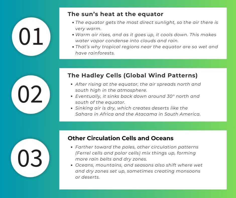
In short: Rain belts form where warm, moist air rises (like near the equator), while dry zones form where air sinks (around 30° north and south). That’s why we can see different extreme events—like floods, droughts, and wildfires happening at the same time.
Watching Earth from Above: NASA Sees the Big Picture
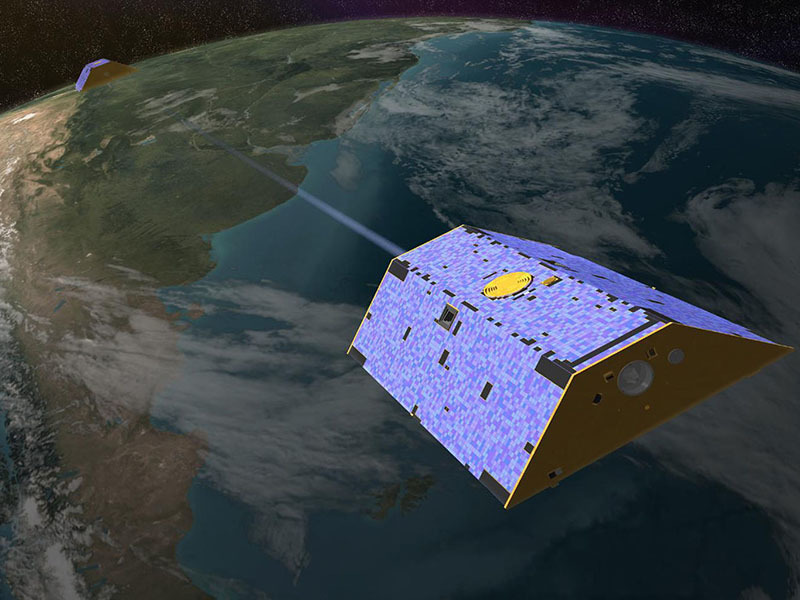
NASA’s GRACE-FO twin satellites measure are 137 miles apart and measure subtle changes in Earth’s gravitational field by measuring the distance between them. These satellites are so precise it can detect changes in distance as small as 10 microns—that’s about one-tenth the width of a single human hair.
I was lucky enough to spend many years with my office embedded in the GRACE Follow-On (GRACE-FO) team—a brilliant, close-knit group that felt like family. GRACE-FO is an extraordinary mission: it measures tiny shifts in Earth’s gravity field, which reveal how water is moving and changing all over the planet. Thanks to this satellite pair, scientists can track melting ice sheets and glaciers, watch groundwater levels rise and fall, and see how the water cycle itself is shifting over time.
NASA scientists have discovered that extreme events—major droughts (long, dry periods) and pluvials (times of unusually heavy rain and flooding)—are happening more often. Not only that—their intensity, meaning how widespread, long-lasting, and severe they are, is strongly connected to global warming.
This picture taken from and animation created by NASA’s Scientific Visualization Studio shows how Earth’s water cycle swings between two extremes—droughts and floods—over 23 years, from 2002 to 2025.
- Red spheres mark dry events (droughts).
- Blue spheres mark wet events (pluvials, or floods).
- Lighter colors show earlier years, while darker colors show more recent ones.
- The size of each sphere shows how intense the event was—the bigger the sphere, the stronger the drought or flood.
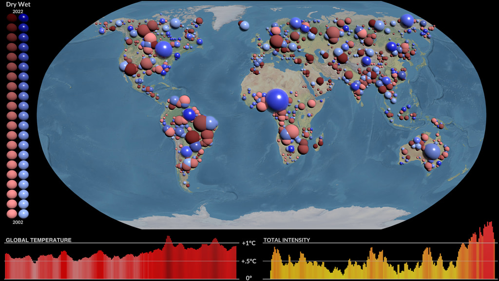
In total, the visualization shows 1,229 extreme events, giving us a powerful look at how water shortages and surpluses have played out across the globe.
Siberia’s Monster Fires: A Dangerous Climate Feedback
Some of the world’s most alarming wildfires are burning far east of Finland, in Siberia’s Yakutia region of Russia. So far this year, more than 4.2 million hectares have gone up in flames—that’s an area bigger than many countries. Scientists worry these fires are destroying wetlands and melting frozen ground called permafrost. When permafrost melts, it can release methane, a greenhouse gas that traps heat even more strongly than carbon dioxide. Melting permafrost also releases microbes and chemicals, including the now-banned pesticide DDT.
By early August, Europe’s Copernicus Atmosphere Monitoring Service reported that the Siberian fires had already pumped 505 megatonnes of carbon pollution into the air. That’s more than the record set for an entire fire season back in 2020.
This creates a dangerous cycle: the more greenhouse gases we release—whether from wildfires or burning fossil fuels—the hotter the planet gets. And the hotter it gets, the easier it is for extreme events like wildfires to start and spread. If we act quickly—cutting emissions, protecting and restoring ecosystems, and getting better at stopping wildfires—we could break this cycle. But unless we do, we’re likely to face many more fire seasons like this one.
Explore how climate change is reshaping our world: https://eco-nana.com/category/climate/


You May Also Like

Earth’s Losing Its Shine (And That’s Not Good)

Melting Permafrost in Siberia is Creating Explosive Craters
